
What is a theodolite? A theodolite is a precision instrument used in surveying. Without it, people wouldn’t have known how tall our mountains were. Theodolites are still used for surveying today, but they have changed a lot to the earlier ones used. These days, theodolites are digital.
The theodolite became common in surveying in the 18th century, but it had existed since the 16th century. The first use of the word “theodolite” was in 1571, in a surveying textbook called “A geometric practice named Pantometria”,written by an English mathematician and surveyor called Leonard Digges. No one knows where the word came from. It could be from Latin, but it has similarities to ancient Greek as well. It could be a mix of both languages. Leonard Digges appears to have invented the theodolite, although there is no concrete evidence for that, and he is the one that named it as well.
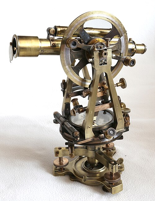
So, what is a theodolite? A theodolite is used to measure angles between two points on a horizontal and vertical plane. Modern theodolites are digital, but the original ones consisted of a telescope that can be moved on any plane. The theodolite has a spirit level so that the operator can be sure it is completely level. The telescope is mounted next to two dials that have degrees marked on them. When you turn the telescope around the horizontal plane, you can find out what the degrees are. Inside the theodolite is a plumb bob, which is a weight on a piece of thread. The weight makes sure the thread is always pointing directly down. When you turn the telescope on the vertical plane, you can measure it on the dial against the plumb bob to work out the vertical angle. If you find a point to measure and use the telescope to fix on another point, you can work out the angle to that object from where you are. Once you’ve got that, it’s simple mathematics to work out any other length of the triangle. I say simple mathematics, but I don’t really understand it.
If you know the distance between the two points, and you know the angles, you can work out the height of something, such as a mountain, using trigonometry. A right-angled triangle has three sides called the adjacent, the opposite, and the hypotenuse. The adjacent is the side at the bottom, the opposite is the vertical side at the end, and the hypotenuse is the long side opposite the right-angle. You can do this because you only need to know the length of one side of a triangle, so long as you have two of the angles, to work out the length of the other sides of the triangle. Let’s say you are trying to measure the height of Mount Everest. First you need to find a point that is level with the base of the mountain. This is pretty difficult to do, which is why the measurements of mountains using theodolites are never completely accurate. Once you have your point, you need to measure the distance to the center of the mountain, which is the length of the adjacent. The side you need to know the length of is the vertical end of the triangle, which is the opposite. You have the angle between the adjacent and the opposite because it is a right angle. When you sight your theodolite on the top of the mountain, it gives you the angle between the adjacent and the hypotenuse. You can work out the third angle because all of the angles in a triangle have to add up to 180°. So, you have one length and three angles. The calculation is the sine of the bottom angle by the theodolite multiplied by the distance to the mountain, divided by the sine of the top angle. Simple.
The larger a theodolite is, the more accurate measurements can be taken from it. The one used to measure the height of Mount Everest weighed hundreds of kilograms. Everest was first measured in 1856 by Sir George Everest and a team of Indian mathematicians. This was during the Survey of India, where they tried to measure as many peaks as possible. They used a theodolite and they came up with the height of 8.839.8 m. They were off by 10.8 m, which isn’t bad because it is extremely hard to get an accurate reading with a theodolite. The ground has to be level, and nowhere on Earth is completely level. Especially if you are getting far enough away from a mountain to measure it. The ground is uneven and the Earth is obviously curved. It is very difficult. Modern theodolites are digital, and they do all of the calculations for you, but they are still not perfectly accurate. The best way to measure the height of a mountain these days is with a satellite. And this is what I learned today.
Try these next:
Sources
https://www.npr.org/2020/11/24/938736955/how-tall-is-mount-everest-hint-its-changing
https://en.wikipedia.org/wiki/Theodolite
https://en.wikipedia.org/wiki/Leonard_Digges_(scientist)
https://www.johnsonlevel.com/News/TheodolitesAllAboutTheodo
https://pwg.gsfc.nasa.gov/stargaze/Strig1.htm
https://www.etymonline.com/word/theodolite
https://www.livescience.com/50691-how-to-measure-mount-everest.html
Image By Colgill – Own work, CC BY-SA 4.0, https://commons.wikimedia.org/w/index.php?curid=89058506