
What is the Sargasso Sea? The Sargasso Sea is the only sea in the world that doesn’t have any land borders. It is located in the Atlantic Ocean and has an area of 3.5 million square kilometers. That makes it roughly 3% of the Atlantic Ocean.
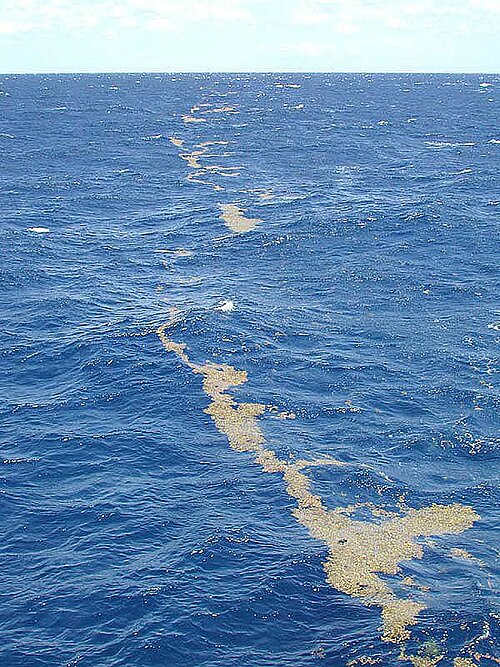
The Sargasso Sea is bordered by four ocean currents. It has the Gulf Stream on the west, the North Atlantic Current to the north, the Canary Current to the east, and the North Atlantic Equatorial Current to the south. Just to the left of the middle of these currents is the Sargasso Sea. It was named by Portuguese navigators in the 15th century after the seaweed that floats there. This seaweed had also been named by the Portuguese navigators. They called it sargaco after a type of rockrose they had back in Portugal. This rockrose had berry-like air sacs, and the sailors were reminded of the rose when they saw the seaweed. The sargasso seaweed floats on the surface and provides habitat and nutrition for a whole host of other species as well. There are two types of eel that are only found here, and some sea turtles use the seaweed as cover until they are big enough to thrive on their own. The seaweed is kept in place by the four currents that swirl around it, keeping the water in the middle fairly still. The water is very calm, blue, and sometimes quite clear. This change in color is what prompted the sailors to separate the Sargasso Sea from the Atlantic Ocean and give it a name. The area often doesn’t have much wind, similar to the doldrums, and ships could get stuck here if they weren’t careful.
Currents in oceans are caused by the heat of the water, the salinity, the wind, and the rotation of the Earth. Ocean currents move in a clockwise direction in the northern hemisphere and an anticlockwise direction in the southern hemisphere. This is caused by the Coriolis effect, which happens because of the rotation of the Earth. Because the Earth is a sphere, it rotates more quickly at the equator than it does at the poles. This is because it has to go farther at the equator. If you are standing on the equator, you are travelling at 1,600 km per hour, and it will take you 24 hours to complete one rotation, which is the entire circumference of the Earth, which is 40,075 km. If you are standing with one foot on the North Pole, it will still take you 24 hours to complete one rotation, but the distance you have to travel is much less than at the equator. The only way to do this is to travel much more slowly, and your speed will be 8 cm an hour. This difference in speed makes winds and sea currents that travel from the equator to the North Pole curve to the right and the winds and sea currents that go from the equator to the South Pole curve to the left. When they go back again, they curve in the opposite direction, and the sea currents become clockwise.
The four currents that border the Sargasso Sea are affected by many different things. The Gulf Stream begins in the Gulf of Mexico (still not going to call it the Gulf of America) and is a very warm and very fast ocean current. It heads from the Gulf of Mexico up the coast of the Eastern United States before meeting the North Atlantic Current. The Gulf Stream is about 100 km wide and 1,000 m deep. It is pushed by winds, which make it so fast. As the Gulf Stream goes north, it cools because the wind on the surface evaporates a lot of the water carrying energy. The water becomes saltier, denser, and starts to sink. The water joins the North Atlantic Current, which pushes it east across the Atlantic. Once across the Atlantic, it splits into two. The colder water goes north, and the warmer water goes south. As the warmer water heads past Europe and Africa, it starts to warm up, and it meets the Canary Current, which heads out from the Canary Islands, just off the coast of Morocco. This water heads south and starts to warm up, before it joins the North Atlantic Equatorial Current. The water is pushed back across the Atlantic, along the equator, by the trade winds. As it goes, it warms up, and then part of it branches north to become the Gulf Stream. And this is what I learned today.
Sources
https://en.wikipedia.org/wiki/Sargasso_Sea
By Unknown author – Ocean Explorer/NOAA, Public Domain, https://commons.wikimedia.org/w/index.php?curid=1175629
https://en.wikipedia.org/wiki/Gulf_Stream
https://en.wikipedia.org/wiki/North_Atlantic_Current
https://en.wikipedia.org/wiki/Canary_Current
https://en.wikipedia.org/wiki/North_Equatorial_Current
https://upload.wikimedia.org/wikipedia/commons/e/ee/Corrientes-oceanicas-en.svg
https://en.wikipedia.org/wiki/North_Atlantic_Gyre
https://oceanservice.noaa.gov/facts/sargassosea.html
https://www.sargassoseacommission.org/sargasso-sea
https://education.nationalgeographic.org/resource/ocean-currents
https://www.un.org/depts/los/global_reporting/WOA_RPROC/Chapter_50.pdf
https://oceanservice.noaa.gov/education/tutorial_currents/04currents3.html
https://education.nationalgeographic.org/resource/coriolis-effect