
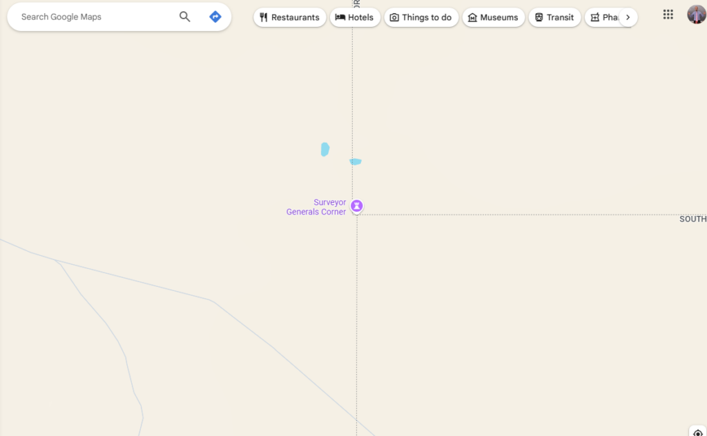
Why is the border of Western Australia not straight? The border of Western Australia isn’t straight because they marked the border from the north and from the south at the same time and missed by 127 meters. If you zoom in on a Google map of Australia and look at the point where the borders of South Australia, the Northern Territory, and Western Australia meet, you can see a little sticking out bit. That is what we are talking about.
Australia has 6 states and two territories. The states are New South Wales, Victoria, Tasmania, Western Australia, South Australia, and Queensland. The territories are the Northern Territory and the Australian Capital Territory. The states and the territories are slightly different. The states have constitutions, state governments, and they can make their own laws. Territories don’t have constitutions or the ability to make their own laws. The territories are governed by the federal government.
All of the states evolved from the six original colonies that Britain established there after 1788. Each colony was a separate entity and there was no connection between them. They all had their own constitutions, courts, and governments, although they were all directly governed by Britain. They had their own laws, but these could be overruled by the government in Britain. After Australia became an independent country in 1901, these colonies became the six states. The Northern Territory was different because it wasn’t a colony. The Northern Territory is in an area that is 40% desert, has a very harsh climate, and is very far from the main areas of Australia that had been colonized. There were not many British people who could get that far and they didn’t think it was suitable to colonize. Settlements sprang up when the telegraph line was built across Australia, but they were very small settlements. The Northern Territory became a territory in 1911 and for a long time it was very sparsely populated. There still aren’t a lot of people living there, but it has become wealthy due to resources. The Australian Capital Territory was created as a place to put the capital. It was equidistant between Sydney and Melbourne, but not controlled by either of them.
The first colony founded in Australia was the colony of New South Wales in 1788. The border was put at 135°East and cut Australia in half. This was actually done because of a treaty signed by Portugal and Spain 300 years earlier. They had divided the world in half between them, along the 135th meridian. This circles the world and it cuts through Australia here. At the time, the Dutch were colonizing the west of Australia and it seemed like a good place to cut the country. In 1803, the colony of Van Diemen’s Land, which is now called Tasmania, was founded. In 1825, Britain was gaining more land and the line was moved 129° and everything to the west was called Western Australia. In 1836, the colony of South Australia was founded as a private colony with private investment. It didn’t do very well and was taken over by the government in 1846. In 1851, a part of New South Wales split off and became the colony of Victoria. In 1859, the colony of Queensland split from New South Wales and became a separate colony.
All of the borders were decided but they actually had to be surveyed and laid out by hand. Australia is such a vast country and the technology at the time was not as reliable as it is today, so there are a few problems with the borders. The small problem we are talking about today is in the border between Western Australia, South Australia, and the Northern Territory. The border had been moved from the 135th meridian to the 129th meridian in the 1820s. In the 1920s, it was decided to officially survey the border. People on both sides of the border were trying to lease land on the other and not knowing exactly where the border was had become a problem.
In 1926, the surveyors began. The border is 1,843 km long, so it was bound to be a difficult task. They knew that they had to keep on the 129th meridian, but the instruments they had at their disposal were not as accurate as we might have today. One group started in the north, another group started in the south and, as you can imagine, when they met in the middle they were ever so slightly out. They were 127 m out. One of the two groups could have started to survey again, but it is a long way, so they left it. There has been talk of redoing the line, but no state wants to lose 127 m of their territory. Whether you move one half of the line west or the other half east, someone is going to lose 127 m. And that is why it hasn’t changed, And that is what I learned today.
Try these next:
Sources
https://www.xnatmap.org/adnm/docs/1genmap/sgcnr/1porter.pdf
https://en.wikipedia.org/wiki/Western_Australian_borders
https://www.foundingdocs.gov.au/places.html
https://en.wikipedia.org/wiki/History_of_Australia_(1788%E2%80%931850)