
Image By U.S. National Park Service, U.S. Geological Survey – http://eros.usgs.gov/lir/midwest-archeological-center, Public Domain, https://commons.wikimedia.org/w/index.php?curid=37307642
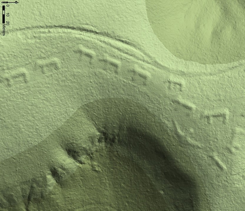
How does LiDAR help archaeologists? It can map the ground down to the millimeter, allowing archaeologists to find the remains of cities and graves that might otherwise remain hidden.
LiDAR stands for Light Detection and Ranging. It is similar to sonar and radar, but it uses light instead of sound waves and radio waves. Sonar, radar, and LIDAR all work on the same principle. They send out a wave (light, sound, or radio), and when the wave hits an object, it is reflected back to the sensor. Then, because the computer in the sensor knows how fast the wave is travelling (light speed for light and radio waves, the speed of sound for sound waves), it can calculate how far away the object is.
LiDAR and radar are both useful tools, but LiDAR can make a more detailed image than radar can. This is down to the wavelength. Light has a much shorter wavelength than a radio wave. That means it is more likely to be reflected back by smaller objects. If an object is small, the radio wave might shoot past it, or just be partially reflected back. However, radar is far more reliable in bad weather. Because of the short wavelength of light, it is far more likely to be scattered if there is moisture in the air, such as rain, fog, and even high humidity. Radio waves also have longer wavelengths, so they can travel much farther.
So, how does using LIDAR help archaeologists? When we stand on the ground, it is very difficult to see if there are any ruins or if any buildings used to be there. If there are visible structures still on the ground, archaeologists can get an idea, but if everything has been removed, there is no way to know by looking that something used to be there. This is where LiDAR helps. If you fly an airplane or a drone with a LiDAR device on it over the same ground, it can map out the surface down to millimeters, and it can tell you if any buildings or roads used to be there. A building that has long since gone will still leave a mark on the ground and underground foundations that are still there could cause the ground to be slightly lower. Foundations, or things buried underground will also affect the vegetation that grows or doesn’t grow on top of them. These are things that cannot be seen from the surface but are things that LiDAR can pick up.
Like a huge number of the technologies we use today, LiDAR was developed for military use. The laser was invented in the late 1950s and LiDAR was invented shortly after that. It was originally used as a targeting device. It could pinpoint a target up to 11 km away with an accuracy of 4 meters. After the technology was released to the public, it was used in meteorology. It could be used to measure clouds and the amount of pollution in the air. It was used by the Apollo 15 mission to accurately map the surface of the moon.
LiDAR used to be extremely expensive and there was no way archaeologists could get access to it, but the price has come down a lot recently. This is entirely due to the development of autonomous cars. A lot of autonomous cars use LiDAR to map out their surroundings. They have a spinning tube mounted on the roof of the car, which is the LiDAR unit. This unit sends out laser pulses in a 360-degree arc. When one of these pulses hits an object, it reflects back towards the car and into the LiDAR units detector. The onboard computer calculates the amount of time the pulse took to come back and knows how far away an object is. The AI part of the computer is able to look at all of the points that the light has reflected back from and recognize them as objects.
Autonomous cars also have something onboard called an Inertial Measurement unit. It is not enough to know how long it takes a light wave to reflect back to the car. The onboard computer must also know how fast the car is moving and what angle it is at. If the car is sloping to the left because of the camber of the road, that will affect the amount of time it takes for a light wave to bounce back from a parked car. If the car doesn’t know it is at an angle and that the light wave is not travelling parallel to the road, it will not be able to calculate the distance to the parked car correctly. The AI unit uses the data from the Inertial Measurement unit and the LiDAR to pinpoint thousands of points of data a second.
So, LiDAR helps archaeologists because it allows them to see marks or indentations on the land that they would otherwise miss. And these marks could be the remains of a city or a house. And this is what I learned
Sources
https://en.wikipedia.org/wiki/Lidar
https://www.synopsys.com/glossary/what-is-lidar.html
https://flyguys.com/lidar-technology-helps-archaeology-industry/
https://www.nationalgeographic.com/culture/article/lasers-lidar-driving-revolution-archaeology
https://cosmosmagazine.com/technology/lidar-how-self-driving-cars-see/
https://www.wevolver.com/article/lidar-vs-radar-detection-tracking-and-imaging