
Why is there a sunken continent underneath New Zealand? There is an almost completely submerged continent called Zealandia in the southern hemisphere.
My questions is actually a little bit misleading. The sunken continent isn’t “underneath” New Zealand. New Zealand is part of this continent.
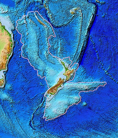
Zealandia has an area of 4.9 million km2, which makes it as large as India and Mongolia combined. However, 94% of it is underwater. The only parts that can be seen are New Zealand, New Caledonia, and some other small islands. Most of the continent is about 2 km underwater.
Zealandia probably separated from the ancient supercontinent of Gondwana about 180 million years ago, along with Antarctica and Australia. Gondwana was a supercontinent that formed about 550 million years ago. There have been ten supercontinents so far on Earth, although it depends on your definition. There will be many more after we are gone as well. Zealandia broke away from Antarctica about 100 million years ago and from Australia about 60 million years ago. It has been stretched into a long, thin shape. Because it is so long and thin, it has become less dense than the rock around it and it has sunk into the Earth’s crust, which is why it is mostly underwater.
Can a piece of land underwater be a continent? Isn’t it just seabed? To be a continent, a piece of land must be elevated above the surrounding area, have distinctive geology, have a well-defined area, and have a crust thicker than the regular ocean floor. Zealandia has all of these. It is elevated above the surrounding sea crust by between 1,000 and 1,500 m. It has valleys, mountains, and a lot of natural mineral deposits. Its area of 4.9 million square kilometers is very clearly defined. Its crust is significantly thicker than the surrounding ocean.
A continent in this area was first hypothesized by the Scottish naturalist Sir James Hector in 1895. He was born in Scotland, but travelled to New Zealand for scientific studies when he was young. He ended up spending four decades of his life there and he is also buried there. When he traveled to some of the islands off the southern coast of New Zealand, he looked at their geology and thought that they were the remains of a mountain chain that once stretched far to the south and east. He was right, but there was no way to prove it during his lifetime.
In the following century, it would have been expensive and difficult to prove that the area was a continent. Other than scientific interest, there was no initiative to spend the money, so nothing much happened for 100 years. In 1995, the idea resurfaced, and the American geophysicist Bruce Luyendyk came up with the name Zealandia. This is the western name. The Maori call the area Te Riu-a-Maui, which means “the hills, valleys, and plains of Maui”.
In the late 90s, the United Nations Convention on the Law of the Sea came into being. This allowed countries to extend their Exclusive Economic Zone up to 370 km from their coastline. Suddenly New Zealand had a wonderful reason to prove that New Zealand was the center of this new land called Zealandia. If they could prove it, their borders would be enormous. Suddenly geologists and scientists had an ample source of funding.
Satellite data was able to prove the existence of the continent. Satellites can track variations in the Earth’s gravity across the seafloor. With this technology, Zealandia is clearly visible. In 2017, it was recognized as a continent and today New Zealand’s EEZ is 15 times the land area of the country. There are a lot of natural resources down there.
There are still lots of mysteries about the continent, but it is too deep to do much investigating. The continent is between 2,500 and 4,000 m under the sea. Maybe one day it will be possible, but for now, drilling is the best that geologists can do.
So, Zealandia is a 94% submerged continent with New Zealand at its center. It is submerged because its shape makes it lighter, so it has sunk. Despite being underwater, it fits all the criteria for a continent. And this is what I learned today.
Sources
https://beta.nsf.gov/news/sinking-zealandia-earths-hidden-continent-linked
https://en.wikipedia.org/wiki/Zealandia
https://education.nationalgeographic.org/resource/zealandia
https://www.geosociety.org/gsatoday/archive/27/3/article/GSATG321A.1.htm